


la Roche-en-Ardenne,vallée des castors

geoffrayLayeux
Utilisateur
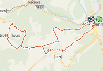

Longueur
12,3 km

Altitude max
393 m

Dénivelé positif
427 m
Km-Effort
18 km

Altitude min
220 m

Dénivelé négatif
426 m
Boucle
Oui
Date de création :
2021-05-15 11:46:11.894
Dernière modification :
2021-05-15 11:47:32.745
4h05
Difficulté : Difficile

Application GPS de randonnée GRATUITE
 SityTrail
IGN / Instituts géographiques
SityTrail Plus
Le monde est à vous
À propos
Randonnée Marche de 12,3 km à découvrir à Wallonie, Luxembourg, La Roche-en-Ardenne. Cette randonnée est proposée par geoffrayLayeux.
Localisation
Pays :
Belgique
Région :
Wallonie
Département/Province :
Luxembourg
Commune :
La Roche-en-Ardenne
Localité :
La Roche-en-Ardenne
Départ:(Dec)
Départ:(UTM)
683969 ; 5561815 (31U) N.
Commentaires